Apple Maps has improved a lot since its catastrophic launch a decade ago. Its much more reliable, and offers really beautiful maps with plenty of detail in most big cities. But it still lags behind competitors like Google Maps and Waze in some key areas.
iOS 16 doesn’t bring a ton of changes to the Maps app – we’re still waiting on offline maps and better support for rural areas – but it does add a long-awaited feature that brings it closer to its rivals.
Multi-stop routing
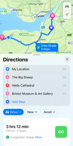
This is the big change for Maps this year, allowing users to add up to 15 destinations into a single trip and have the app calculate your whole journey in one go.
To do so, search for a destination and tap the directions button as usual, and be sure you have Drive selected. (Multi-stop routing currently only works for driving directions.) Adjust the leaving time if need be and choose whether you’d like to avoid tolls or motorways.
You can then press Add Stop to search for another location to add to your itinerary. Note that Maps won’t alter your route to optimize the journey – locations are kept in the order you add them. Luckily, you can reorder the stops by dragging the handles to the right of each item. You can delete stops by swiping left over them and tapping Delete. When you’re happy, tap GO to start the trip!
If you’re driving and need to make an ad hoc stop for gas or snacks, you can use Siri commands to insert another stop to your route. When we beta-tested this feature, we found it difficult to consistently get this to work, but Siri’s understanding should improve over time.
Travel cards and transit
Public transit is much more seamless in this latest edition of Maps. When getting transit direction, the app calculates how much each possible route would cost to help you choose which one to take. You can select to see those figures as cash fares or transit card fares.
Speaking of transit cards: if you have any in your Wallet app, they will now show up in Maps too. That means you can check your balance and add funds without switching apps.
UI redesign
Maps’ directions interface has been tweaked slightly this year. You can choose between Drive, Walk, Public Transit, Cycle, or Ride Share via a new drop-down box. There are also drop-down lists for travel time and avoiding tolls/highways, making those options much easier to find.
Detailed expansion
Apple made significant improvements to the detail in Maps last year with iOS 15, but rolling it out worldwide is a slow process. With iOS 16, the following countries join the party: Belgium, France, Israel, Liechtenstein, Luxembourg, Monaco, Netherlands, New Zealand, Palestinians Territories, Saudi Arabia, and Switzerland.
Apple’s very best maps, complete with 3D tourist attractions and locations (like the one shown above) are still reserved for select big cities. The list is growing though, and this year these cities are included: Atalanta, Chicago, Las Vegas, London, Los Angeles, Melbourne, Miami, Montreal, New York, Philadelphia, San Diego, San Francisco, Seattle, Sydney, Toronto, Vancouver, and Washington DC.


